
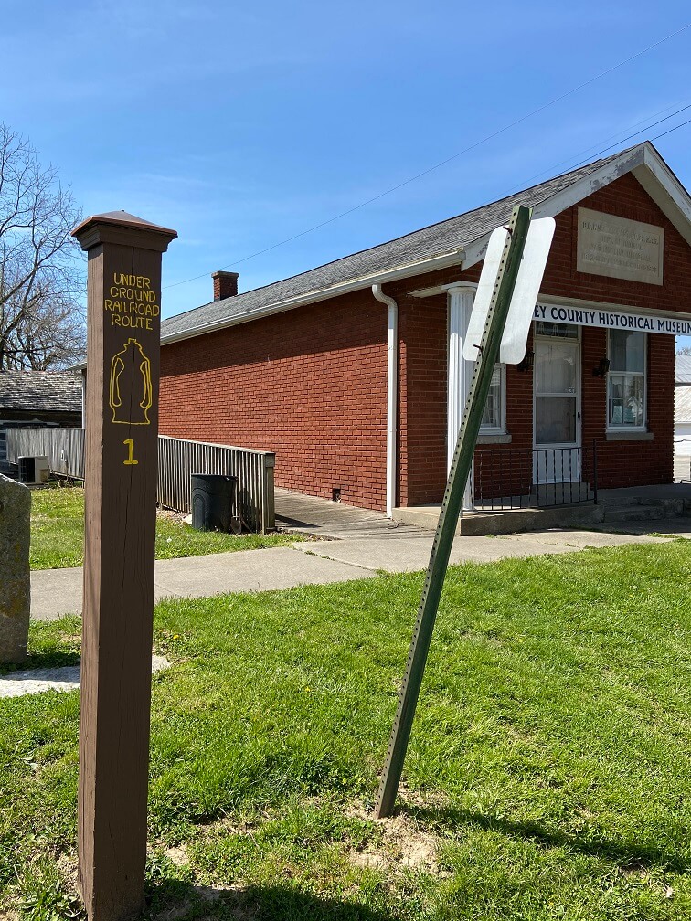
Start trip meter 0.0 at the Ripley Count Historical Society (RCHS) Archives Building, on Washington Street on the Ripley County Courthouse Square in Versailles. Head south, left on Tyson Street, right on Main Street, one block to Water Street, Tour Stop 1, at trip meter 0.2 is just beyond the RCHS Museum.
TOUR STOP 1 (39° 4′ 14″ N 85° 15′ 5″ W) — Pioneer Brookville Trace: Some fugitive slaves came up from Vevay and Patriot through Versailles, then north along the old Delaware and Brookville Traces.
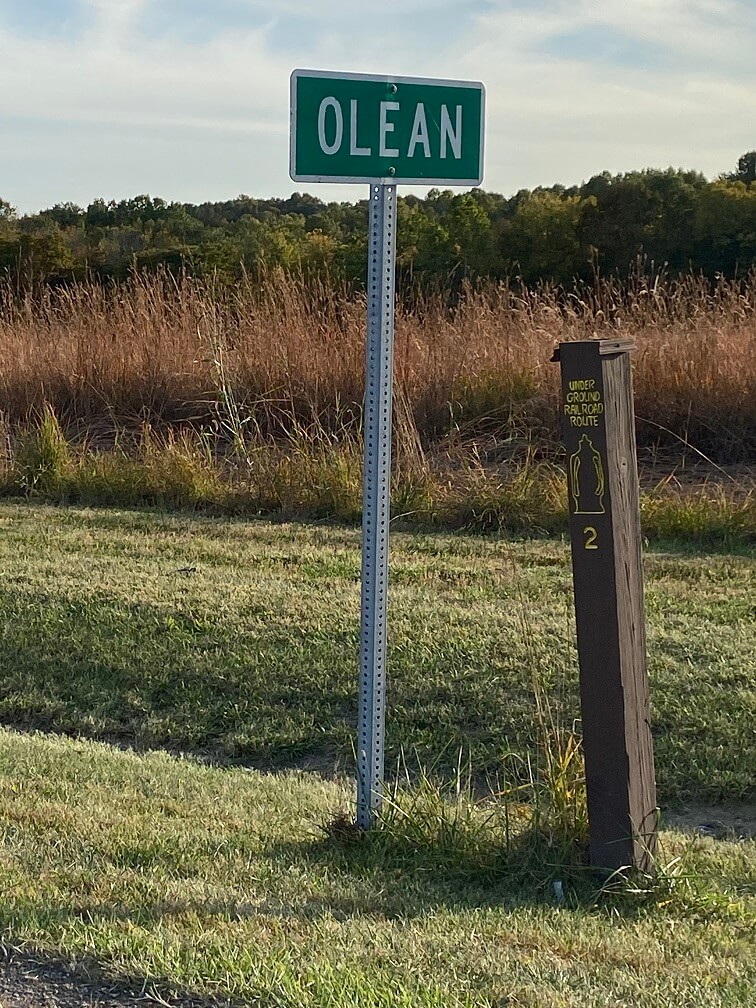
>>Continue south on Main Street, cross U.S. 50, at the junction of S.R. 129 turn left. Go south to the 6.1 mile mark to Tour Stop 2.
TOUR STOP 2 (38° 59′ 41″ N 85° 13′ 14″ W) — Charles F. Steyer and the Olean German Settlement is on the right side of S.R. 129 at the Olean town sign. Most German settlers were passively anti-slavery, but Charles F. Steyer, an immigrant from Germany, took an active part in the Underground Railroad operations in Olean and Benham.
>>Go south on S.R.129 through the town of Olean to trip meter 7.45 to Tour Stops 3 and 4 at the Weakman Cemetery on the right side of the road.
TOUR STOP 3 (38° 58′ 36″ N 85° 12′ 51″ W) — Mt. Pleasant Church, Separate Baptists: An anti-slavery congregation with several Revolutionary War veterans provided safe haven for fugitive slaves here.
TOUR STOP 4 (38° 58′ 36″ N 85° 12′ 50″ W) — Raccoon Creek Free Black Community: To the east along Raccoon Creek a settlement led by Moses and Henry Green, former slaves, provided safe haven for those coming from Rising Sun through Friendship. You are welcome to visit this beautifully restored cemetery, but please be careful to leave nothing but footprints behind.
>>Continue south on S.R. 129 to the junction of County Road 900S in Cross Plains (trip meter 9.9). Watch for the historic marker for Buchanan Fort at the turning point. Turn right onto County Road 900S and go to trip meter 10.2. Tour Stop 5 will be on your left.
TOUR STOP 5 (38° 56′ 34.5′ N 85° 12′ 57″ W) — Squire Paugh’s old mill site and Rev. Alexander Sebastian and the Separate Baptists in Cross Plains. The oldest fugitive slave trail came across to Cross Plains from Canaan. Anti-slavery Baptists in Canaan, at IndianKentuck Creek, and Rev. Sebastian Alexander and Squire Paugh’s Separate Baptists in Cross Plains formed a secure route leading up to Olean. Squire Paugh’s mill was a landmark safe house for the southern region.
>>Continue west on County Road 900S (it turns into County Road 925S). The road becomes narrow blacktopped; continue straight ahead when the road becomes gravel and winds through lovely backwater lands. At trip meter 15.7, Tour Stop 6 will be on your right at the junction of County Road 225W just in front of the tree stump at Haney’s Corners.
TOUR STOP 6 (38° 56′ 20″ N 85° 18′ 19″ W) — Haney’s Corners marks the southern edge of the 1,000 acre farm of Edmund McGuiness who brought his slaves up from Kentucky in 1817 and freed them here. In 1839 Archibald Lewis married Phoebe McGuiness, a freed slave; Lewis became leader of several African American families here. He purchased 40 acres just north of Haney’s Corners in 1842. A teen-aged boy who attended dances and parties there said that these Free Blacks often went from Madison to Benville, major centers for the Underground Railroad. Archibald is buried near Canaan and his son, Preston Lewis, is buried in the Shelby Christian Church Cemetery.
>>Continue west on County Road 925 W to the junction of U.S. 421 then jog right and then take the first left, continuing west on County Road 900 W. At the Old Michigan Road and the former Jefferson Proving Ground fence turn right, go north one mile to the junction of County Road 800 S and Old Michigan Road (trip meter 20.65). Tour Stop 7 will be on the left.
TOUR STOP 7 (38° 59′ 26″ N 85° 21′ 54″ W) — Sylvan Grove: This was the northern edge of Sylvan Grove, the family farm of the Honorable James Harrison Cravens, Unites States Representative, State Senator and Legislator, Vice President of the Free Soil organizing convention, and a leading anti-slavery attorney in Indiana.
In 1854 J. H. Cravens sold 20 acres of his land in Section 24 to James Banks, the leader of a group of tri-racial (Native American, African-American and White) families from North Carolina and Virginia. In 1856 Cravens sold another 65 acres to Banks. By 1860 there were 40 members of this African American rural community. When Cravens moved to Osgood, this community moved into more secure lands in what was to become the Jefferson Proving Grounds from the 1940s to the 1990s. Today most of the property lies in the Big Oaks Wildlife Refuge and is under strict visitation guidelines due to unexploded ordinance on the property.
>>Turn right onto County Road 800W and continue to U.S. 421, Tour Stop 8 will be on the right at the stop sign.
TOUR STOP 8 (38° 59′ 26″ N 85° 21′ 54″ W) — Rexville: Rexville was the center of a major pro-slavery area that stretched north to Correct. This contrasted with the generally anti-slavery position of those living in and near Benham and Olean.
>>Turn left onto U.S. 421; continue north (trip meter 4.3) to Correct. Turn right onto County Road 450S to trip meter 26.9, site of the old Samm’s Schoolhouse. Tour Stop 9 will be on your left.
TOUR STOP 9 (39° 0′ 31″ N 85° 16′ 43″ W) — Samm’s Schoolhouse: Arms and ammunition were found hidden here after the Civil War, presumably by the Knights of the Golden Circle of Rexville. Local legend says that Celia Mahoney prayed every night that the Confederates would win, and John Deburger’s father (Marquis Marcellus Deburger) and Mr. Delaney were said to be active in the pro-slavery Knights.
>>Turn around and go west on County Road 450S, cross U.S. 421. Tour Stop 10 is on your left in one half mile.
TOUR STOP 10 (39° 0′ 31″ N 85° 17′ 17″ W) — Pleasant View Methodist Episcopal Church: After the Civil War, the Methodists in Correct purchased the old Mt. Pleasant Church (Tour Stop 3) in Olean and moved the entire church to this site. They renamed the church Pleasant View Methodist Episcopal Church.
>>Return to Versailles by way of U.S. 421, continue across U.S. 50 to RCHS Archives on the Courthouse Square.