
The Tour Stop Posts were not in place at the time of this post, but visitors should be able to follow the directions below and find the tour stops. Two locations are cemeteries and several others are marked with State or County historic markers.
Start trip meter 0.0 at the Ripley County Historical Society (RCHS) Archives Building, on Washington Street on the Ripley County Courthouse square in Versailles. Go 0.2 miles south to U.S. 50. Turn right. Go west on U.S. 50 to Michigan Road (trip meter 5.7). Turn right and go north on Michigan Road through Dabney to the junction of County Road 325 N at Otter Village. Turn left onto County Road 325 and go to the Otter Village cemetery at trip meter 9.3. Tour Stop 1 is on your left as you pull into the cemetery parking area.
Tour Stop 1 (39° 7′ 18″ N 85° 20′ 54″ W)— Otter Village: Buried in this cemetery are Harmon Smith and Stephen Andrews, two of several abolitionists who aided runaway slaves in this area. The Freedom Freewill Baptist congregation was established by Elder Ichabod Sheldon, in 1845. Later Rev. Courtney and Rev. David Hanna, a Methodist Protestant preacher, served here. Dr. Andrew Cady, the Underground Station Master in Holton, moved his membership to the Freedom Church. In the early 1850s, the Ohio & Mississippi Railroad (O&M) rights-of-way were obtained from Holton through Dabney (then called Poston) to Osgood. Irving Taylor, a teenager in Holton, said that he and several others acted as conductors for Dr. Cady following the O&M track.
>>Carefully back out of the Otter Creek cemetery parking area and return to Michigan Road. Turn left. Go north on Old Michigan Road to County Road 350N at trip meter 10.0. Turn right onto County Road 350N and go east to Osgood on Railroad Avenue. At trip meter 12.8, cross the B&O-CSX tracks on Walnut Street. Immediately turn left and go one half block east on O&M Street. Tour Stop 2 will be located on your left at the site of the old O&M depot.
Tour Stop 2 (39° 7′ 47″ N 85° 17′ 33″ W)— O&M Depot: Originally called Claytown, the village changed its name to Osgood in 1854 in honor of District Manager A. L. Osgood, the civil engineer for the Ohio & Mississippi Railroad. The O&M was the only broad gauge railroad in Indiana, and it connected New York, Philadelphia, Baltimore and other east coast locations with St. Louis through Cincinnati.
>>Continue east on O&M Avenue to U.S.421 turn left and cross the railroad tracks. Turn right onto SR 350W. This is the old O&M track right of way. At trip meter 13.0, turn right onto Fairgrounds Avenue. Tour Stops 3 and 4 will be located on your left just before the B&O-CSX overpass at trip meter 13.2.
Tour Stop 3 (39° 7′ 58″ N 85° 17′ 20″ W)— Osgood Abolitionists: From this point for the next two to three miles a number of abolitionists lived along Fairgrounds Avenue. John Ewing’s farm to the north, John Andrews, the architect-builder, was at the corner just past the underpass, and Isaac Levi’s farm lay just to the south. The Shepherd house was next to Andrews then Dr. Jeheil Mullin’s house was at the junction of Harlan Street. Some of the Levi children lived further along Fairgrounds Avenue (the area later known as Vines Spring) where Alan Burton, Levi’s son-in-law lived. James Muir, the father-in-law of William Love and William Howe, Underground Railroad activists in Napoleon, also lived nearby.
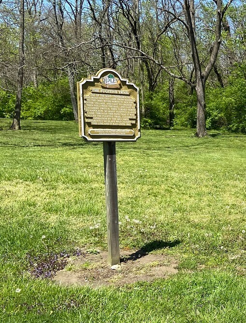
Tour Stop 4 (39° 7′ 58″ N 85° 17′ 20″ W)— The Fugitive Trail: Left before the underpass, an old grassy lane along the creek bed led to the O&M track. East of the underpass, a lane extends south through the Andrews and Levi lands. This is the old Fugitive Trail through Osgood.
>>Go east on Fairgrounds Road to trip meter 13.4 at the corner of Harlan Street. Tour Stop 5 is on the right.
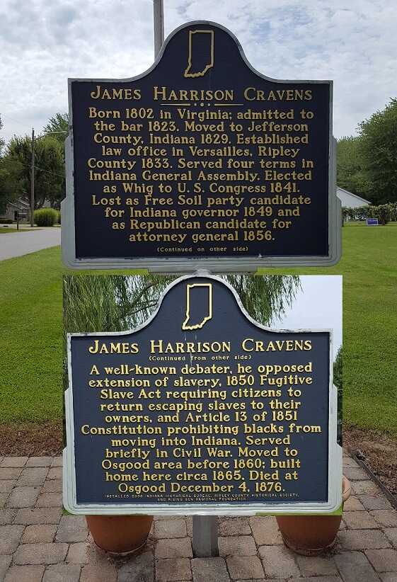
Tours Stop 5 (39° 7′ 58″ N 85° 17′ 9″ W)— Mullins-Cravens: This was the home of Dr. Jeheil Mullins and later James H. Cravens, both leading abolitionists. Runaway slaves were hidden in the fruit cellar here.
>>Continue east to trip meter 14.4. Tour Stop 6, on the left, is Perseverance Cemetery.
Tour Stop 6 (39° 7′ 58″ N 85° 17′ 9″ W)— Vines Spring: In 1843 trustees of the Perseverance Methodist Church included Alan Burton, the son-in-law of Isaac Levi, a leading abolitionist. Burton’s home was located on the old Brookville Trace (now Finks Road) and the O&M Railroad track.
>>Turn left onto Finks Road and go north to S.R.350. Turn right at trip meter 15.3. Go east to trip meter 16.2 to the Laughery Switch bridge. Carefully pull off the road before the bridge. Tour Stop 7 is on your right at the bridge.
Tour Stop 7 (39° 9′ 0.9″ N 85° 14′ 42.1″ W)— Laughery Switch: Site of 1863 CSA clash with local militia and abolitionists. Colonel Grigsby of John Hunt Morgan’s raiders forced R. J. B. Roberts to push O&M cars off the track into the ravine then burned the bridge.
>>Continue east on S.R.350 to trip meter 16.7. Carefully pull off onto the edge of the road. Tour Stop 8 is on the left, near the trees on the Robert’s land.
Tour Stop 8 (39° 9′ 0″N 85° 14′ 42″ W)— R. J. B. Robert’s Store: The home directly across the road dates to 1840. On the left side was the store, which was an Underground Railroad safe house. The route to Napoleon turned north to Mud Pike Church.
Continue east to trip meter 17.7. Tour Stop 9 is on the left at the barricade.
Tour Stop 9 (39° 8′ 57″ N 85° 13′ 40″ W)— Gustave Vayhinger: The German immigrant who first settled in Cincinnati, Ohio, set up homestead on Castetter Creek (later known as Greasy Run) here. He made vinegar and wine although he abstained. His was a safe house. Fugitive slaves were said to drop off the O&M Railroad and get food and water in his cellar behind the house.
Turn east on S.R.350 to trip meter 18.7.
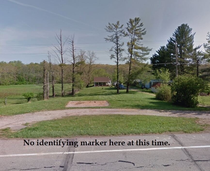
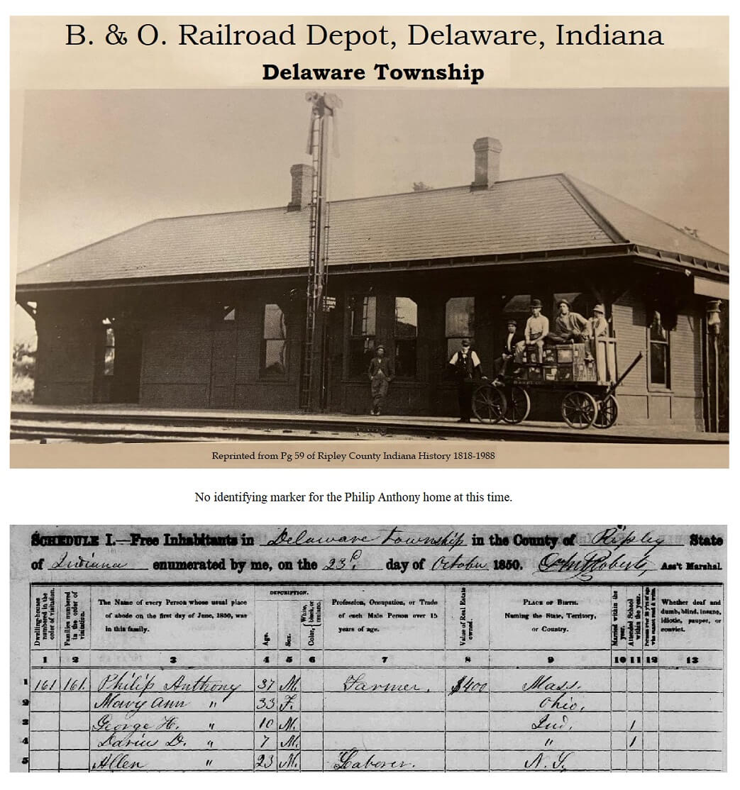
Tour Stop 10 (Appx: 39° 8′ 51″ N 85° 12′ 35″ W)— Philip Anthony in Homer: His son Darius told of his father’s Underground Railroad activities here in Homer. Anthony located on old Delaware Road leading from Versailles and was active with the Freewill Baptist Church near what is now Lookout. (See also North Polar Star Route, Stops #7, #9. & #10.). This route was closely allied to North Polar Star Route.
>>Turn right on S.R.129, go to trip meter 25.2. Turn right onto U.S.50 return to Versailles, right (trip meter 29.1) mile on Main Street to the Ripley County Courthouse.